

For decades now, Geospatial technology has proven to be a viable tool that is being used to achieve Sustainable Development Goals (2030). As many advanced countries have been using this technology but how many sectors have adopted it into their activities? Are we utilizing it as we should? How many policies have been made in this regard? How do we use Geospatial technology and its capabilities in addressing climate-related crises? We don’t have to wait until we have the entire tool needed to build climate resilience before we start to act on the climate change crisis. We need to start deploying technology that will help boost our environmental immunity and not destroy our environment. One such technology we have today is Geospatial technology. Over the years, it has helped us to manage disasters, evaluate progress, prevent disasters and build resilience. We have been seeing extreme weather events happening around the world as such are overwhelming critical infrastructures. During my interaction with Taiwo Ogunwumi, a geospatial consultant, he stated that; why there is more impact of climate change is because we are not utilizing the tool as it should.
Climate change is now a global reality and
to reduce the vulnerability of the impact of climate change using geospatial
technology as Taiwo stated that there are four components of Disaster Risk Management that act as an action against any crisis
which includes; Preparedness, Prevention, Response and Recovery. This will have
to do with predictive mapping of climate-induced hazards that might occur at a
given geographical location, making policies that can enhance natural hazard
prevention and further build climate resilience. Also, using remote sensing
technology (which is a subset of Geospatial technology) could help to
understand flood impacts on livelihood, ecosystem, and population and help
emergency experts and policymakers to facilitate necessary responses at
flood-affected locations. Disaster occurs when there is a hazard, when
people are vulnerable, exposure and lack of adaptive capacity. For instance,
Flood and Drought early warning information will help farmers to be more
prepared and help in improving their coping and adaptive capacity to the future
climate-induced crises. As well, geospatial could help fix policies that
will aid system change and not climate change. According to him, any kind of
hazard can easily be monitored through GIS, be it changes in temperature,
amount of rainfall, desert encroachment and other forms of hazard.”
Climate change arises from different
sectors and as such needs us to act from different angles in solving the
climate crisis. Remote sensing technology is one of the effective tools to
monitor forest canopy, biodiversity and tree covers which could help to avoid
future pandemics, through the geospatial analysis of the environment it will be
easy to know whether we are expanding our biodiversity resources or we are
depleting them because they serve as a regulator of air quality. It is
important that we adopt the use of geospatial technology at all sectors and
institutions that exist within the country to strengthen our environmental
immunity which will build humanity security from any form of present and future
crisis.
Also through geospatial technology, we can
have access to data that is needed in predicting climate change and this will
help the government and other relevant environmental stakeholders in
formulating policy to address and respond to climate-induced crises.
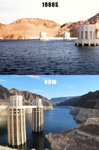
“Geographic Information System (GIS) is a tool to monitor changes in sea level, ecosystem resources, and predict drought and flood. Hence, this technology will help to build climate resilience."
oladosuadenike32@gmail.com


0 Comments
We are open to listening to your comment.